
You may have seen these weather satellite images (below) and you perhaps wondered how they were received and decoded. Well, actually it is not that tricky! The harder part is getting a good quality image. I will go through step by step covering what I have used, tried, failed at and also the various hardware, software as well as the different satellites out there.

Which satellites are out there
I should start out by saying that there are many ways to go about doing this. The NOAA satellites on 137MHz:
- NOAA 15 - 137.6200 MHz (1998)
- NOAA 18 - 137.9125 MHz (2005)
- NOAA 19 - 137.1000 MHz (2009)
The bandwidth is 36-38kHz and FM mode.If you set to 40kHz you should be safe. More on this later. The NOAA-19 APT image resolution is 4-km (2.5-mi).
There are the ones I will be focusing on above. Others in case you are interested are:
- METOP-A (2006)
- METOP-B (2013)
- METEOR-M N1 (2009)
- METEOR-M N2 (2014)
The newer Meteor line of satellites (M2 specifically) from Russia, which provides much higher resolution. As well as some geostationary satellites. The latter is perhaps a different article as I would not recommend starting with those.
Geostationary Orbiting Environmental Satellites (GOES) Weather Satellites are:
- GOES-13 (2006) 75° W “East coast view” - Not Active
- GOES-14 (2009) 105° W on-orbit storage/Standby
- GOES-15 (2010) 135° W “West coat view” - Not Active
- GOES-16 137.2° W "West View" - Replaced 15
- GOES-17 75.2° W "East View" - Replaced 13
GOES satellites are very directional and use 1.6941GHz. If you are interested in building a receiver for these, please visit the Setting up a GOES Geosynchronous Weather Satellite Receiver using a Raspberry Pi page on this website.
Needless to say the NOAA APT satellites orbit (move around the earth) and they pass a few times overhead at each location on earth, generally twice a day but at times more passes can be captured. You will need to know when. More on this in the software section.
To offset hosting costs, this page is sponsored by:

Hardware needed for satellite reception
Basically we are looking at 2-3 pieces of hardware depending on how serious you get about this. For sure you will need a receiver.
These could be:
- A Scanner radio (May need some mods)
- Dedicated Receiver (for 137MHz Weather Satellite)
- Basic SDR Dongle ($10-30 range)
- Advanced SDR Dongle (AirSpy, FunCube or HackRF one)
- VHF/UHF Ham Radio Receiver and/or A Raspberry Pi
If you want to receive weather satellites using the raspberry pi, please check out my other page on this website: Setting up a NOAA VHF Weather Satellite Receiver using a Raspberry Pi

This unit is easy to find...You can look at the photos of the inside of this unit as well as some other similar units on my PiAware ADS-B pages of this website.
I have used ALL of the above at some point and had pretty good luck with all the AirSpy and even better with the HackRF One or the dedicated receiver below I own WeSatCom APT-06 from Germany were tied for first place. Note that Scanners and the ham radios may have bandwidth issues. The signal is 30+ kHz wide signal which prevents narrow FM modulation receivers from being used. If you are not compensating for doppler effect the receiver bandwidth should be set to 50 kHz or so to receive all the data of the modulated signal.
The dedicated receiver will take care of the doppler issues as will some plugins with some of the SDR software if you are concerned about this. It WILL give you better images if you do compensate for this obviously, but not needed.
The one I used is pictured below and I use this in conjunction with a Signalink USB Soundcard I had laying around. This seems to work by far the best for me.

The next thing you need is an antenna. This ideally should be a circular polarized one. There are many different designs and you may even have some luck with a good old fashioned 2m ham radio antenna. Here are some of the common antenna types:
- Quadrifilar Helix (QFH) Antenna
- Turnstile Axial Mode Antenna
- V-Dipole Antenna
- Double Cross Antenna (DCA)
The Quadrifilar Helix (QFH) Antenna seems to have the better reception of any of the others. There are a ton of plans on the internet for designing these. These can be made from copper wire or copper pipe (the one I picked). Here is an online calculator to help you with your design. These are also available commercially and some people make them for you as well if you have no time. Just look online!
For the Turnstile Axial Mode Antenna, if you choose to build your own, visit here. Easier to build, might be good to experiment with.
The V-Dipole Antenna is basically like the old rabbit ear TV antennas tilted. In fact I would say this is a good initial test, not good for a permanent installation.
Lastly the Double Cross Antenna (DCA) will not screw you over! It is actually my second favorite and is easy to build, works well and can even be purchased commercially.
The Antenna I use (on the W6AER Antenna Farm) is pictured below. It is a home brew antenna made entirely of PVC pipes and copper pipes. Everything I needed I got in a 30 minute home depot trip. My design in a combination of a few I found online. I also added the balun (coax wrap on top) as well as the preamp as seen in the picture. It is up about 10 feet.

 Lastly, you may want to consider adding a pre-amplifier. While using a good cable is not that important on a short run since you are dealing with 137MHz there is not too much loss, but if you are looking to get larger clear images (like above) and have a long cable run like I do (60 feet) it is a must. When running this length you will need good coax, however. An example would be an RG-213.
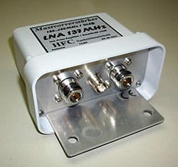
One I heard is good is the LNA 4 ALL and it is a wideband low noise amplifier. The one I use is by a very small German company called Nachrichtentechnik and sometimes you can also find them on eBay. In fact, I had to grab their image of an old auction page so I can give them some credit for this cool product. This unit is 20db gain and it is the best thing I have found so far!

Above is a preamplifer I used for a while before going with a mast mount one. It is easier to feed power to the mast mount and no loss introduced by adapters. Note the Ferrite! I use these all over to keep noise low. This was mounted in a weather tight box I found online.

Software options for successful decoding
The one thing you will need regardless of the hardware you pick is the decoding software:
Weather satellite image processing:
- Mac/Linux/Windows: WXtoImg
WXtoImg Version 2.11.2 Beta Available
Many improvements, including ALSA audio support under Linux and Banana Pi (and other ARM) support can be found in the 2.11.2 beta. Download.
WXtoImg Version 2.10.11 Released
The latest stable version is 2.10.11. Download.
PLEASE NOTE: The software is no longer being developed and the site has been down. But you can still download the free version of the software on the internet. The above links are from the wayback machine.
Things to adjust and to be on the lookout for in the software are:
- In the Recording Options: Change your sound card to the one you are receiving on. Virtual (like VB-Audio Virtual Cable) or actual (like a Signalink)
- Set Your Location so it knows where you are and can do calculations
- Update Keplers: This will ensure that your software has the information about the satellite passes.
- In the Satellite Pass List check upcoming satellite passes for your location. The higher the MEL (Maximum Elevation), the stronger the signal, therefore 90 degrees means the satellite will pass directly above you.
- The little volume bar on the bottom needs to be GREEN. If yellow or red, you are over driving your audio.
- Under File select Record. Then Select "Record and auto process," and "Create Image(s)." Click Auto Record.
- Leave software running to Record and check back for results after the pass (or you can watch live during)
- For images like above go to Enhancements and select MCIR map color IR
- Map Overlay Options may need to be looked at but seem usually fine for me

Above you will select the input. Yours will likely not look as busy but since I am a FlexRadio user I have many virtual audio channels. Signalink is the hardware option and the Virtual Audio Cable above is the audio pipe used by SDR# (SDR Sharp) which is my other preferred method using an AirSpy.

Last step, make sure you go to this tab under file and tell it to actually record!
You will likely need software to control your SDR(just one of these)depending on the model here are some options or just the control if using dedicated hardware:
- Windows: SDR Console
- Windows: SDR# (For AirSpy)
- Mac/Windows: Cubic SDR
- Mac/Linux: GNU Radio
- Mac/Linux: GQRX
- Windows: HDSDR
- Windows: APT Control for Hardware Solution
If you are using one of the very basic SDR Dongles, you will need to Download Zadig, this will also your system to recognize the device. Check the website for step by step instructions.
Lastly depending on your configuration, you will need to chanel your audio from the software to the decoder. This is accomplished by using Audio routing softwareand here are some options:
- Windows: VB-Audio Virtual Cable
- Mac: Soundflower
- Windows: Audio Repeater
There are others but these are the ones I know and used by most out there.
To offset hosting costs, this page is sponsored by:
If you are just looking to track the orbit or want to use a hand held antenna, here is software to assist you:
- Orbitron (PC)
- Gpredict (For linux)
- SatPC32 (PC)
- Ham Radio Deluxe
- Heavens-Above.com (Web)
- WXtrack (PC)
- SkyView Satellite Guide (iOS)
You may also want to check my Ham Radio Links Page for a more comprehensive and updated list. If you are using a stationary antenna, you will not need to be concerned about this.
Other resources on Weather Satellites
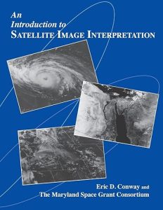
For further reading on the topic, this is a great resource. Click on image to take you to get more info:
There are many sites out there dealing with Weather Satellites, both types. Here are some of the useful general links I did not mention above.
- RTL-SDR or Go Directly to their Tutorial
- Instructables
- Also RTLSDR on Reddit is a good source
I hope you learned something new and would love to get your feedback on this as well as hear some success stories.
If you find something incorrect and/or have an update, I would really appreciate if you could let me know by contacting me. I like to keep things as up-to-date as possible. Thank you! - Lucas / W6AER